In February 2021, the Netherlands Environmental Assessment Agency published a blog post titled “A choice for 2050: The Netherlands more compact, more polycentric, or more diffuse?”. The post discussed three scenarios of urban development in the country, based on the ESPON project Sustainable Urbanization and Land Use Practices in European Regions (SUPER). The scenarios were: compact, polycentric, and diffuse, with each scenario having different implications for land use, sustainability, and quality of life.
The post raised a fundamental question: how should urban areas grow and accommodate the increasing demand for housing and services? This question is not unique to the Netherlands. Many cities worldwide face similar challenges in balancing the needs of people and the environment. One of the possible solutions is infill development, which refers to the reuse of vacant or underutilized land within existing urban areas. Infill development can reduce urban sprawl, increase density, and revitalize neighbourhoods.
However, infill development is not without obstacles and trade-offs. It may also entail higher costs, social conflicts, and design constraints. Moreover, infill development may not always reflect what people want. For example, some may prefer low-density living in greenfield areas, while others may value proximity to urban amenities and services. So, how can planners and policymakers reconcile these preferences with the goals of sustainability and efficiency?
‘Drone Shot of City’ by Towfiqu barbhuiya on Pexels
The history of infill development versus city expansion can be traced back to the origins of urbanization itself. Throughout history, cities have grown and changed in response to factors such as population growth, economic development, technological innovation, social movements, and environmental challenges. Different urban forms have emerged due to these factors, such as compact, sprawling, polycentric, and vertical cities.
In general, urban development can be classified into two types: extensive and intensive. Extensive development refers to the horizontal spread of urban areas, often at the expense of natural or agricultural land. Intensive development refers to the increase of density and diversity within urban areas, often through infill development or vertical layering.
The choice between extensive and intensive development has varied across time and space, depending on the historical context and the preferences of urban actors. For example, in the 19th century, many European and American cities experienced rapid industrialization and urbanization, which led to overcrowding, pollution, and social problems in the inner city. As a result, many people moved to the suburbs or the countryside, seeking more space, comfort, and health. This trend was facilitated by the development of transportation and communication technologies, such as railways, automobiles, and telephones. Urban sprawl has become a dominant form of urban development in many parts of the world.
In recent years, infill development has become more popular and desirable as a way to deal with the problems of urban sprawl and promote smart growth. Infill development has different pros and cons depending on how it affects the environment, the economy, the society, and the space. Infill development can also be compared with city expansion to see the trade-offs and synergies between them.
‘Bird’s-eye view photography of white concrete building’ by CHUTTERSNAP on Unsplash
For the Netherlands, the three scenarios of urban development for 2050 from the Netherlands Environmental Assessment Agency are: compact, polycentric, and diffuse. Each scenario has different impacts and trade-offs on land use, accessibility, liveability, environment, and economy. Compact development ranks well for most indicators, except for urban green spaces and housing demand. Polycentric development is good for most indicators overall. Diffuse development is the worst for most indicators, except for affordable housing and housing demand. Therefore, the choice of the urban form should be based on careful consideration of the advantages and disadvantages of each scenario.
However, in the second half of the 20th century, urban sprawl also faced increasing criticism for its negative impacts on the environment, the economy, and society. Some of these impacts include loss of biodiversity, soil erosion, water pollution, greenhouse gas emissions, traffic congestion, infrastructure costs, social segregation, and loss of cultural heritage. In response to these challenges, many urban planners and policymakers advocated for more compact and sustainable forms of urban development, such as infill development. Infill development was seen as a way to revitalize existing urban areas, make use of underutilized land and buildings, reduce infrastructure costs, enhance accessibility and mobility, promote social diversity and cohesion, and preserve natural and historical resources.
Yet, infill development also faces some obstacles and trade-offs. Some of these include higher land prices, regulatory barriers, community opposition, design constraints, displacement of existing residents or businesses, loss of open space or privacy, and increased noise or pollution. Moreover, infill development may not always align with the desires of residents. Some people may prefer low-density living in greenfield areas for various reasons, such as affordability, lifestyle preferences, cultural values, or personal aspirations.
Therefore, the history of infill development versus city expansion is not a simple story of one replacing the other. Rather, it is a complex story of how different urban forms have coexisted and competed with each other over time and space. The choice between infill development and city expansion is not only a technical or economic one but also a political and social one. It reflects different visions of what a city should be and how it should grow.
Another example is Los Angeles County, California, where infill developments positively impact local housing prices. The impact starts before the start of the new project. New developments built on teardown sites have a more substantial effect than those made on vacant or underutilized areas. The pricing of units in the new development also affects the impact. Infill development could increase the value of existing neighbourhoods and generate positive benefits for local residents. Furthermore, infill development is here an effective way to solve the local housing shortage.
‘Rows of colorful roofs of houses in modern village’ by Kelly from Pexels
In conclusion, the choice between infill development and city expansion is complex, reflecting different visions of what a city should be and how it should grow. While infill development can reduce urban sprawl, increase density, and revitalize neighbourhoods, it may also entail higher costs, social conflicts, and design constraints. Moreover, infill development may not always reflect what people want. Some may prefer low-density living in greenfield areas, while others may value proximity to urban amenities and services. On the other hand, city expansion can provide more space, comfort, and health for some people but also negatively impact the environment, economy, and society. The choice between these two options should be based on careful consideration of the advantages and disadvantages of each scenario.
As we move forward into the future, we must ask ourselves: what kind of cities do we want to live in? Do we want cities that are compact and sustainable or sprawling and inefficient? Do we want cities that prioritize people or cars? Do we want cities that are diverse and inclusive or segregated and exclusive? These are not just technical or economic questions but also political and social ones. They reflect our values, our aspirations, and our vision of the good life. The choice is ours to make.
If you know Cape Town exclusively from a tourist’s perspective, you will likely have certain images that come to mind, like the stunning beaches, mountain views, unique flora, penguins, sunset cruises and trendy eateries. Due to the South African Rand being a cheaper currency, you may also experience quite a change in buying power while visiting. Suddenly, you may be able to afford accommodation with an ocean view, eating out each meal and buying the most expensive wine on the menu.
One can paint a rather romantic picture of Cape Town, but this is also a picture of a lifestyle and experiences that most city residents will never experience. Many tourists are faced with this reality in the car ride from Cape Town International Airport to their accommodation because upon exiting the airport, you are greeted by views of the informal dwellings of Gugulethu – a township where thousands of people live without running water in their homes and where violence is part of everyday life. However, the tourist will likely arrive at their accommodation in a suburb like Camps Bay, where the median property is sold for R12 750 000 compared to Gugulethu’s mere R360 000 (around 605 000 and 17 000 euros, respectively).
Current racial separation in Cape Town
While the 20-minute car ride the tourist took is hypothetical, it does, however, demonstrate a broader phenomenon in the city: the extreme wealth and racial divide. According to the IMF, South Africa is the most wealth unequal country in the world, with 20% of the population holding 70% of the wealth. Wealth inequality is also heavily racialised, and Statistics South Africa found that in 2017, the annual median expenditure for whites was more than ten times higher than that of black Africans.
The broader context of racial injustice in South Africa during the Apartheid era
Apartheid was a system of institutionalised racial segregation and discrimination enforced by the South African government from 1948 to the early 1990s. Under the system, people were categorised by race and received rights based on this categorisation. The white minority enjoyed a privileged position, while people of colour were systemically oppressed and denied political rights. Apartheid translates to “separateness”, and the government relentlessly and violently enforced the separation of people of different races by introducing laws like the following:
Group Areas Act (1950)
This act assigned specific residential areas to different racial groups. This law resulted in the relocation of millions of people of colour, sometimes with brutal force – tearing them from their communities and largely locating them to the edges of cities where they experienced limited economic opportunity and a lack of infrastructure, services and amenities.
Reservation of Separate Amenities Act (1953)
Different public facilities like parks, beaches, hospitals and public transportation were assigned to be used by different race groups. The facilities available to people of colour were limited and inferior to those offered to white people.
Prohibition of Mixed Marriages Act (1949)
Marriage between white and non-white individuals was prohibited. This act ended up tearing families apart, and this law’s social effect is still felt today.
The Apartheid government’s attraction to modernism
The National Party (NP), the political party in control from 1948-1994, was attracted to modernism for several reasons. Firstly, The NP was attracted to modernism as a global movement because it was associated with the developed world and the white Western culture they admired. Secondly, modernism was associated with efficiency and rationality, which fit well into the NP ideology of white supremacy and modernisation. Lastly, the apartheid government could use modernistic ideas to justify and legitimise their implementation of racial separation – a good example of such an idea is that of Le Corbusier, who offered a vision for the physical separation and zoning of different functions within the urban fabric. The apartheid government would simply argue that offering “separated development” for different race groups is just more “efficient” and “organised” due to the differences in language and culture.
Cape Town Civic Centre in Hertzog Boulevard, Cape Town
How modernism shaped Cape Town in three different areas
City centre
Following the principles of modernism, several large-scale changes were made to the Foreshore area in Cape Town. Large, monolithic buildings replaced historic buildings, and two major highways were built to connect the city centre. Still today, one can see the stereotypical modernistic picture of high-rise buildings that stand in contrast with large open spaces – urban design commonly criticised for its lack of human scale.
Forced removals in certain neighbourhoods
As previously mentioned, the apartheid government did not want people from different race groups to mix; they also wanted to keep prime locations in cities “clean” (white). This resulted in the forced removal of an estimated 3,5 million people in South Africa from 1960 to 1983. In Cape Town, the most well-known example of a neighbourhood destroyed by forced removals, is District 6.
“And you will find those areas are all areas of prime property importance, because what had happened was when an area has been proclaimed as a white area, people of colour of course, had to get out. And if you owned property in those areas, the government would make an offer for your property which was way below market-related prices. And if you refuse to sell it, they would take your property, and the word they use ‘expropriate’. Then they would give you what they thought it was worth, which was even less than what they offered you in the first place. And then they kick your butt out of there.”
Joe Schaffers, a former resident of District Six and one of the founders of the District Six Museum
District 6 was a vibrant neighbourhood where people from many races, cultures and religions lived together until it was designated as a “whites-only” area under the Group Areas Act. In 1966, the apartheid government began removing residents and bulldozing their homes and business to make way for new, modernist developments like office blocks, highways and apartment buildings. The forced removals continued until 1982, and over 60 000 people were displaced. Former District 6 residents can still paint clear pictures of the destroyed community’s heartbreak and trauma. They share stories of seeing their parents cry for the first time and the suicides committed by some of the people affected.
“In 1970, the government sent in the first bulldozer. Then, they started demolishing all our homes. In fact, it took them 11 years to do that. Gradually, street by street. You know, many people died of broken hearts. My father was also in his early 60s when he had to leave his home in 1974. I still remember how my father cried. He didn’t want to go because District Six was his home.”
Noor Ebrahim, a former resident of District Six and one of the founders of the District Six Museum
Residential areas on the outskirts of the city
The apartheid government created large-scale, high-density residential areas on the outskirts of cities for the non-white population. These areas are called “townships” and were also separated by racial group. They were meant to accommodate the growing non-white population while keeping the inner-city areas reserved for white people. Townships are characterised by a lack of public amenities like parks, schools and healthcare facilities while also limiting access to economic opportunity as they are located far away from the CBD and do not have suitable transport options. This is the answer if you were wondering where the former District 6 residents were forced to move to. They were usually placed into cheaply built accommodations, but some people also received no housing and ended up living in informal settlements where they had to make makeshift shelters.
The townships still live on today, and while government efforts are made to improve them, they are still vastly underserved and riddled with crime. Gangs are prevalent in especially the Cape Flats, and in 2018, it was estimated that 100 000 were members of gangs in this area alone.
The Fall of Apartheid
The regime started showing cracks in the late 1980s. Various factors contributed to the ultimate demise of apartheid, including the tireless efforts of anti-apartheid activists (both within South Africa and internationally) and international exclusion. The 1990s were characterised by several transformative and hopeful events like the release of Nelson Mandela from prison in 1990, his democratic election in 1994, the country hosting and winning the 1995 Rugby World Cup, and the establishment of the Truth and Reconciliation Commission (TRC), also in 1995. The TRC provided a platform for victims of human rights abuses during apartheid to share their stories and seek reconciliation.
Conclusion
Today, South Africa is rather different to what it used to be during the apartheid era, and the Constitution is widely regarded as one of the most progressive and inclusive constitutions in the world. Even though significant improvements have been made, South Africa is still far removed from what the Constitution describes it should be.
“The democratic South Africa that celebrates its 26th birthday today is not the fair and just country that it should be – that many in 1994 dreamed it would be.”
Archbishop Desmond Tutu in 2020
Cape Town still serves as a case study of how oppressive powers can use modernistic planning to leave a large-scale impact on urban environments and how, despite having a reformed political system, the effects will be felt by generations to come.
When strolling around on the rare sunny day in Groningen, you notice people really take advantage of getting some natural vitamin D. Almost every inch of the city becomes a social ground, a place for chit-chat, relaxation, and leisure. In the world of urban design, it is interesting to notice how unofficial gathering places become the most social place to be. The stairway is an example of this phenomenon that can be observed in multiple places throughout the city such as parks, university grounds, shops, and so on. On these sunny days, the main function of stairs shifts to a state where it becomes actually challenging to use stairways as functional pathways. For periods of time in a day, stairs become social hubs.
Dynamic Activities Bringing Life to Stairways
There are many types of staircases, but almost every design attracts either deliberately or unknowingly. People are attracted to visually pleasing, lively spaces and places and use them as social hubs or observe the city drama. The staircase of the Academy building on a sunny day is packed with students taking a break from classes or studying in the UB. They come here to sit and chat, have a quick pastry snack with a coffee from Jumbo or Albert Hein, people-watch or sunbathe as a break from a day in the library. The Academy building is one of the most iconic cultural heritage landmarks in the city, offering a sense of cultural connection to Dutch architecture, which is eye- and soul-pleasing. Naturally, people are attracted to places like this. In this case, it is a place for many budget-conscious students to enjoy a free visit or even a cheap vending machine coffee, which can be seen as a great luxury to many.
People enjoying public stairs in Groningen, pictures by Nina Zrubáková
Directly across the Academy building, is the university’s library and the social staircase phenomenon repeats, but in this case, indoors. Here, the weather does not play a role in attracting people. It is one of few places in the library where people can talk and sit, so naturally, people take advantage of it and gather in groups to chit-chat over a snack between studying. On busy days such as during exam periods these stairways are packed with students, and passing between floors becomes a challenge. In the lively city center, options to sit down without having to pay are hard to come by. The city center is not seen as a place for relaxation, more so as a place for taking part in fun activities and spending money. Despite this, you can still find people sitting on a staircase to someone’s house near the front door. This might seem invasive to many because it blurs the distinction between public and private space. Having the feeling of going unnoticed while resting and chatting on someone’s stairs beats the feeling of invading someone’s private space.
Global Showcase
From the evolving architectural periods, stairs have been seen from many functional and symbolic perspectives, their importance bringing us many beautiful grand staircases and unique designs. Full of cultural identity, social aspects of stairs can be seen worldwide. The famous Metropolitan Museum in New York City has an iconic stairway that has played a role in many movies and is used for the world’s biggest fashion event, the Met Gala, yearly. During the rest of the year, the stairs are seen as a social hub by many inhabitants and used as a public place for gathering, leisure, and people-watching. Paul Goldberg accurately commented on this phenomenon by saying:
“There are some stairs in the city like those in front of The Metropolitan Museum of Art that are arguably more important urban events than the buildings to which they lead”
In Munich, the stairway leading to Glyptothek, the sculpture museum, was such an important public space that even after closing the whole building for reconstruction, it sparked an initiation to design a temporary replacement. The stairs to Paris’ Sacré-Coeur offer an incredible panoramic city view, drawing large crowds to enjoy it, inviting street performers, large amounts of photoshoots, and even proposals.
On the left the Metropolitan Museum (source: Kai Pilger, Wikimedia), on the right the Glyptotheke (source: Glyptotheke)
Rethinking the Urban Design Role
Despite the benefits they bring to public spaces, stairs do have flaws; particularly they pose limitations to people with limited mobility. Multiple unique designs offer solutions to this; it is just in the hands of architects and urban designers. Inclusive designs can be seen more so in newly built public spaces, such as Vancouver’s Robson Square, where accessibility is not an issue for anyone, regardless of their level of ability.
Stairways have the potential to be more than just useful architectural components. The urban design has a space to create welcoming and interesting areas that promote community, foster interactions, and improve the general well-being of people and users by purposefully taking the social elements of stairways into account. Rethinking the stairway layout may help to create inclusive, bright, energetic urban spaces that encourage social interactions and a feeling of community.
The way we interact in a public space is seen everywhere in urban design, it helps to provide for needs in shared spaces and shapes the existing and future urban designs. Stairways all over the world have become unofficial gathering places, prompting many social interactions. They are free places to have a cup of coffee and a pastry snack, soaking in the sun while enjoying the city. Stairs become iconic features that make an impact due to their visual state, symbolism, and interaction.
Many European cities brand themselves with their rich, dynamic history. However, few cities can say about themselves that they have such a dynamic history as Lviv. For starters, this Ukrainian city has been in five other countries over the past century before becoming part of Ukraine in 1991. All these border changes over the years have naturally affected the city’s identity. High time for an eventful journey through the tragic history of this forgotten geopolitical plaything of the European powers. In case you lose the thread while reading: the table below summarises the steps of the time journey.
Name
State
Period
Lemberg
Austria-Hungary
1772-1918
Lviv
West Ukrainian People’s Republic
1918-1919
Lwów
Poland
1920-1939
Lemberg
Nazi-Germany
1939-1945
Lvov
Soviet Union
1945-1991
Lviv
Ukraine
1991-today
It is June 1915, in the middle of the First World War. The prince of Austria-Hungary breathes a sigh of relief: the kingdom’s third-largest city has been recaptured from the Russian army. Ever since the Polish partitions in the 18th century, Lemberg has been in the Austrian crown country of Galicia. Originally Polish, the foundation of a university and its strategic location allowed it to develop into a multicultural and dynamic city where Poles, Germans, Jews, Armenians and Ukrainians lived peacefully side by side. However, the authority of the Austrians did not last for much longer.
On November 11th, 1918, World War I ended. From the ruins created by the war, a number of new states were able to develop. People belittled for centuries by the great powers were now redeveloping their own states. One of those states was Poland. Lemberg was initially the capital of the Western Ukrainian People’s Republic. However, this state proved unable to withstand Polish supremacy, and so Poland annexed the city and surrounding areas in 1919. Lemberg became Lwów and until September 1939, Lwów remained a centre of Polish and Jewish culture. The Germans? They moved away to their homelands, Austria and Germany, respectively, because of the negative economic conditions for them.
Lwów’s heyday came to an end when in 1939 Poland was claimed by the Soviet Union and Nazi Germany through the infamous Molotov-Ribbentrop Treaty. Lwów was annexed by the Soviet Union, but when the Germans invaded the Soviet Union in 1941, the town’s Ukrainian residents were only too happy to see an end to this occupation. However, the Germans, as elsewhere in Europe, kept a firm grip and deported Lviv’s entire Jewish population to extermination camps. An entire culture, all its citizens included, was wiped out in just three years.
After defeating Nazi Germany, the Soviet Union saw its chance: what they had been deprived of after WWI, they could now take back to themselves. After all, Poland had been completely destroyed during the war, and the Germans had to pay the price for losing the war. Poland tried in vain several times to retake Lwów but to no avail. In 1945, Lwów became Lvov, and the city henceforth fell under the Ukrainian Soviet Socialist Republic. However, the many Poles still living in Lvov were a thorn in the Soviets’ side. Coincidentally, the renewed state of Poland had a similar problem: in the parts Poland was allowed to annex from defeated Germany, many Germans still lived. They were expelled from the country without pardon. Their empty houses could be filled straight away with Poles from Lvov: the Soviets thought it would be an interesting idea to deport the ‘surplus’ citizens to their ‘motherland’, and so Lvov could, in turn, be filled with citizens from the rest of the Soviet empire. The hitherto largest population group was, again, in just a few years, completely obliterated. Lvov had become a Ukrainian-Russian city in a Polish-Austrian shell. No one by now knew of the multicultural, Central European glory that characterised Lvov until deep into the 20th century. The city had become part of the periphery of the Soviet Union and had no ties to its past in anything. Until 1991.
With the collapse of the Soviet Union and, at the same time, the creation of independent Ukraine, Lvov had a key role. Through migration from the rest of western Ukraine, the city became a hotbed of Ukrainian national culture, which sought to turn its gaze back to its old brethren in central Europe. In 1991, Lviv became the city’s official name, and since then, attempts have been made to connect with Europe with varying degrees of success. One of the best opportunities the city has had for this was the organisation of the European Football Championship in 2012, in which Lviv was a playing city. High efforts were made to improve the tourist infrastructure, but large tourist flows failed to materialise. Has the border of the old Soviet empire now penetrated too far into the minds of Europeans?
Expressions of Ukrainian nationalism after the 2014 revolution, picture by Dion Glastra (2014)
By 2016, when I first visited this city and a hundred years after the starting point of our time travel through the geopolitical history of the already 25-year-old Ukrainian Lviv, the two main population groups living there at the time had been exterminated or taken away. The city has been part of as many as six countries. Of course, the story does not end here; quite the contrary. During the Ukrainian protests of the past two years, Lviv, even more than other parts of Ukraine, sought rapprochement with the EU. In late 2013, the Lviv region’s administration even briefly declared independence from the central authority in Kyiv before pro-Europeans won there too.
The story of this forgotten city illustrates how big an impact political decisions can have on the identity of cities. Whereas 100 years ago, Lviv was a multicultural, dynamic city in the heart of Europe, today, Lviv is a city mentally on the periphery of our continent and has to make extreme efforts to have any image at all in the minds of Europeans. Will Lviv succeed in its ambition to one day return to the heart of Europe?
Tip: despite the huge demographic tragedy that has plagued Lviv, the city itself is wonderfully well preserved and, therefore, well worth a visit. Unfortunately, it appears to be a very bumpy road for Lviv to become the new city trip hype of Europe. Since February 2022, the right of Ukraine to be a nation has been contested once again. Russian attacks have hit the country and made many people flee. Although Lviv itself has not been on the front line, the city’s social fabric has been severely affected by the influx of refugees. But let’s hope that the war is over soon so that we can support the Ukrainian people by visiting this beautiful city and its kind people!
Finally, an overview of Lviv’s demographic changes between 1900 and 2001.
Population
1900
1931
1959
1989
2001
Poles
49%
50%
4%
1%
1%
Jews
27%
32%
6%
2%
0%
Ukrainians
20%
16%
60%
79%
88%
Russians
0%
0%
27%
16%
9%
Others
4%
2%
3%
2%
2%
The population composition of Lviv between 1900 and 2001. ‘Other’ includes Germans, Armenians and Belarusians.
This article was published in Dutch in 2016 and has been translated and updated by the original author. Visit the original here.
Cities are evolving at high speed. They must adapt to multiple challenges, leading to the competition of interest. As David Harvey, an urban theorist and geographer, pointed out that this competition could lead to a misunderstanding of the best decision. Further warning that these competing interests leave out ‘the man’, meaning that citizens have little power over the decision made in the city. Manuel Castells, a sociologist, believes that social inequalities must be challenged in the urban environment of global cities in forms of urban activism.
Urban activism is lifting citizens’ voices in planning for the built environment. Urban or civic activism implies that citizens show interest and initiative in what is being done (or not done) in their built environment and how it is governed. The grass-root enterprises can benefit the community in a way the authorities cannot. Additionally, urban activism can range from different types of involvement, such as self-organized events to shed light on an issue; making direct changes in the urban environment through private funds or citizens’ participation; educating people about urban issues and concepts; or simply protesting.
Examples of urban activism in action
In Munich, Germany, two architecture students devised a solution to improve public space. A place that had been temporarily shut-down site for renovation was used by many people to gather and enjoy the sunlight. The two students, Maria Schlüter and Nick Förster prepared a project and a proposal for sponsors of an alternative solution for public space in front of the shut-down building. For a couple of months, these students, with the help of others worked on regenerating this public space by installing custom-made benches to bring people together again and enjoy the sun outside, as it used to happen here before. Similarly, three architectural students from Bratislava, Slovakia worked on a project to regenerate public space due to its derelict state. Places of neglect that previously served little to residents for public recreation were the place of interest. Three university students Lucia Adameková, Viktor Kasala, and Ján Urban, decided to start an initiative called “Krásy Terás” (in translation: terrace beauties) to regenerate the public terrace spaces for people to enjoy and bring residents closer.
Urban activism can bring awareness in many shapes or forms. In Bishkek, Kyrgyzstan, the ‘Urban.kg’ project was launched to educate citizens about urban matters and increase people’s initiative. Multiple artists voice their minds on the streets with their art worldwide. For better city planning, several initiatives collect and visualize data across the city; an interesting one is Safetipin, which promotes women’s safety in the city.
The impact of urban activism on urban planning
For better city planning, several initiatives collect and visualize data across the city; an interesting one is Safetipin, which promotes women’s safety in the city. Many scholars already suggest citizens’ involvement in some form is necessary for better cities and better urban planning. Urban activism allows citizens to voice their opinions through direct action or provides education within urban studies. From all around the world, we can see various examples of practices of urban activism that help within the urban environment and regeneration where authorities cannot. Additionally, it can advocate for those who are “unseen”, “unheard”, or left out, such as the disabled or elderly. In today’s world of competing interests and fast pace of changes, providing across communities and generations secures the multigenerational and intergenerational needs of cities that are many times left out of the agenda.
This article is published in the booklet of the Geo Promotion Conference 2023, themed “0 to 100: Solving multi-generational spatial needs”
The concept of adaptable housing is becoming increasingly relevant in the Netherlands as the country faces a number of housing challenges. As the number of students in need of housing continues to grow, and universities and university cities are struggling to keep up. However, this is not the only housing challenge the Netherlands will face in the coming years. As the population ages, there is expected to be a growing demand for elderly-suitable housing that can accommodate the unique needs of this demographic group.
That is where adaptable housing comes in, offering a flexible and modular solution: living spaces that can be easily modified to meet the changing needs of residents over time. This type of housing is designed with the future in mind, ensuring that it can adapt to the changing demands of the market. The ability to make changes to the layout, fixtures, and accessibility features means that adaptable housing can meet the needs of a variety of residents. By offering a customizable solution, adaptable housing can provide a comfortable and suitable home for people from all walks of life.
Benefits of adaptable housing: addressing housing shortages and cost-effectiveness
And there are plenty of reasons why adaptable housing is such a hot topic. For one, it helps to address the issue of housing shortages by reducing the need to build new housing units every time there is a change in demand. This is particularly important in the Netherlands, where suitable places to build are scarce, and the high cost of real estate and construction make it challenging to build new housing units quickly enough to meet the demands of a growing population. Furthermore, adaptable housing offers a cost-effective solution for addressing changes in housing demand over time. The cost of modifying existing housing units is often less than building new ones, making adaptable housing a more sustainable and economical option.
Another key benefit of adaptable housing is the sense of security and comfort it provides to residents. Residents can feel confident that their homes will be able to accommodate their changing needs as they grow older or when their living conditions change. This is particularly important for elderly residents, who may have or develop mobility or health issues that require them to live in homes that are specifically designed for their needs. By providing adaptable housing, developers and providers can ensure that a supply of suitable accommodation is available to meet the needs of this growing part of the population.
When it comes to designing adaptable housing, there are some key considerations. Firstly, the design of the housing unit must be flexible enough to allow for easy modification. This typically involves using modular construction techniques, allowing individual elements of the housing unit to be easily replaced or reconfigured. Secondly, the design must take into account the unique needs of the target audience. For example, when designing student housing, the unit should be able to accommodate multiple occupants and provide space for studying and socializing. When designing elderly-suitable housing, on the other hand, the design must take into account the mobility and accessibility needs of the residents.
Conclusion
In conclusion, adaptable housing offers a solution to some of the housing challenges faced by the Netherlands, both now and in the future. By providing flexible, modular living spaces that can be easily modified to meet the changing needs of residents over time, adaptable housing can help to address the shortage of student housing and meet the growing demand for elderly-suitable housing. With its cost-effectiveness, versatility, and potential to meet the needs of different groups, adaptable housing is a promising solution to the housing challenges faced by the Netherlands, but also in other countries.
This article is published in the booklet of the Geo Promotion Conference 2023, themed “0 to 100: Solving multi-generational spatial needs”
Once upon a time, an American businessman was on vacation in a seaside village in Mexico. There he met a fisherman docking his boat after a catch. Impressed with the fish’s quantity, the American asked the Mexican how long it took to catch them. The Mexican replied, “only a little while.” The American then asked why didn’t he stay out longer and catch more fish. The Mexican said he had enough to support his family’s immediate needs. The American asked, “but what do you do with the rest of your time?” The Mexican fisherman said, “I sleep late, fish a little, play with my children, take siestas with my wife and stroll into the village each evening where I sip wine, and play guitar with my amigos. I have a full and busy life.”
The American scoffed. “I have an MBA from Harvard, and can help you,” he said. “You should spend more time fishing and buy a bigger boat with the proceeds. With the proceeds from the bigger boat, you could buy several boats, and eventually you would have a fleet of fishing boats. Instead of selling your catch to a middle-man, you could sell directly to the processor, eventually opening up your own cannery. You could control the product, processing, and distribution,” he said. “Of course, you would need to leave this small coastal fishing village and move to Mexico City, then Los Angeles, and eventually to New York City, where you will run your expanding enterprise.”
The Mexican fisherman asked, “But, how long will this all take?” The American replied, “Oh, 15 to 20 years or so.” “But what then?” asked the Mexican. The American laughed and said, “That’s the best part. When the time was right, you would announce an IPO, and sell your company stock to the public and become very rich. You would make millions!” “Millions – then what?” The American said, “Then you could retire. Move to a small coastal fishing village where you could sleep late, fish a little, play with your kids, take siestas with your wife, and stroll to the village in the evenings where you could sip wine and play guitar with your community.”
This parable gracefully reveals to us the basic needs for a full and happy life: livelihood security, having a family, friends, pastimes and, in general, belonging to a community. It also exposes the pitfalls of rat-racing wealth hoarding, being similar in wisdom to the Biblical Parable of the Rich Fool which warns of greed because “a man’s life consisteth not in the abundance of the things which he possesseth” (Luke 12:16-21). As the fisherman told the businessman, he works enough so as to “support his family’s immediate needs”. Now do not take this literally as an indictment against owning a business, but ponder about how the fisherman was happy living in the moment –carpe diem in Latin- and fulfilled his family’s multigenerational needs.
The Concept of “Gemeinschaft” and Its Importance in Urbanism
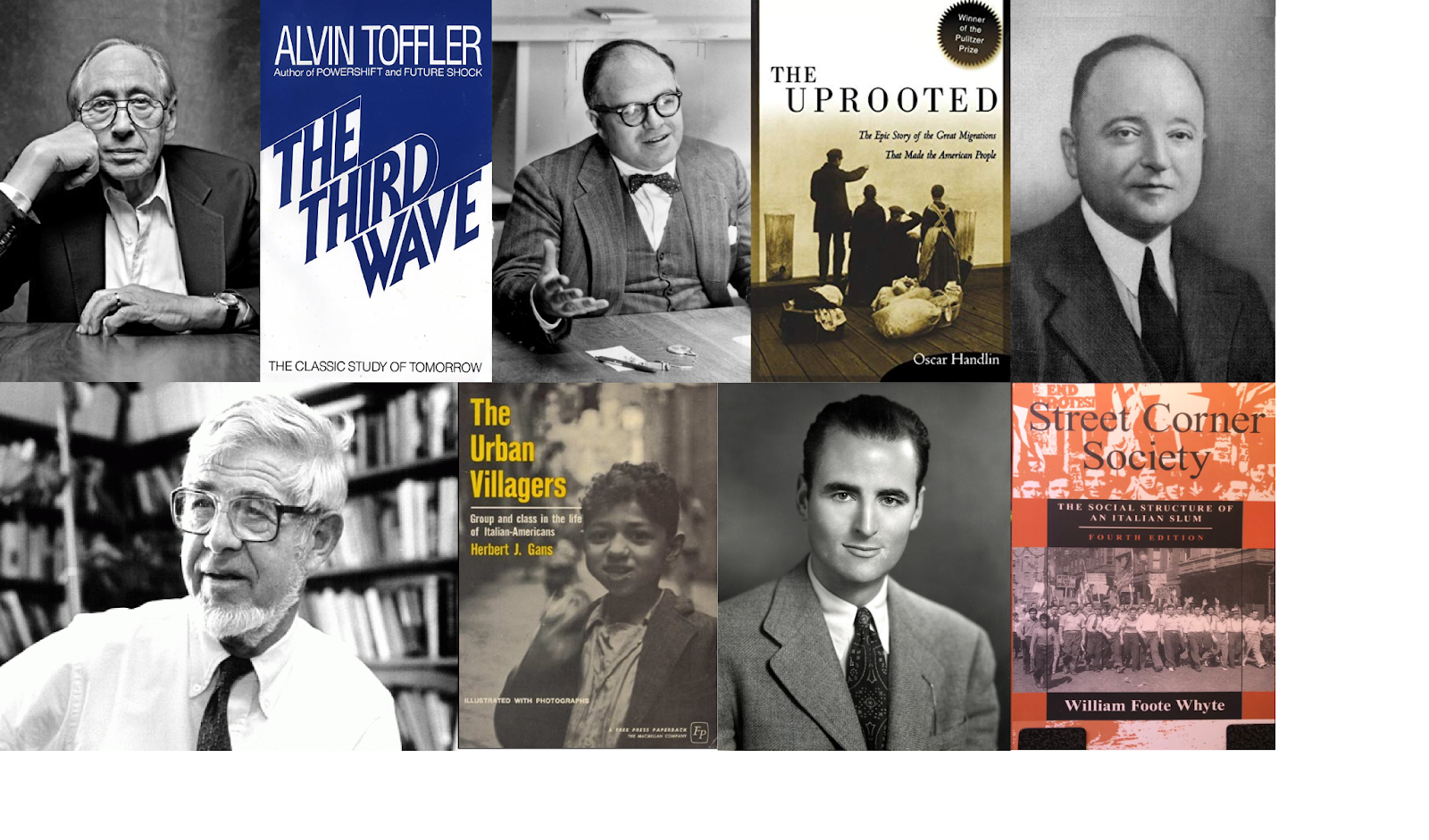
One concept of urbanism present in our little story was that of “gemeinschaft” or community. This implies proximity and a concrete geographical setting such as that seaside village, but it also provides routine and familiarity to the human life. But modernity, especially since the widespread urbanization, has bred a new kind of alienation or solitude of the city dweller. Alvin Toffler described in his 1980 book “The Third Wave” how the industrial revolution ended living in the same household with your extended family.
Immigration historian Oscar Handlin portrayed in “Uprooted” (1950) the archetype of immigrants as peasants guided by religious convictions with no familiarity with wage work or urban settings. Further still, University of Chicago sociologist Louis Wirth studied the psyche of big city residents in “Urbanism as a Way of Life” (1938), arguing that three characteristics of cities lead to a peculiar “urban personality”: large population sizes, social heterogeneity and population density.
However, others have argued that there is no universal “urban way of life”; instead, ethnicity plays a more important cultural role. Sociologists Herbert Gans in the “The Urban Villagers” (1965) and William F. Whyte in “Street Corner Society” (1943) believed that people tend to maintain their pre-existing cultures and personalities. Places like Little Italy in New York or North End in Boston fulfilled “an important but unrecognized function in the city by providing a stable community for newcomers from different parts of the world and for people with low incomes.” We can see how ethnic neighborhoods were a lifeline for multigenerational needs.
eighborhoods were a lifeline for multigenerational needs.
From top left corner: futurist Alvin Toffler (1928-2016), author of “The Third Wave” (1980); immigration historian Oscar Handlin (1915-2011), author of “Uprooted” (1950); sociologist Louis Wirth (1897-1952), author of “Urbanism as a Way of Life” (1938); sociologist Herbert Gans (1927-), author of “The Urban Villagers” (1965); and ethnographer William F. Whyte (1914-2000), author of “Street Corner Society” (1943)
What about contemporary immigrants and foreign ethnics who settle in a new country and city? How can these people fulfill their multi-generational gemeinschaft needs? In the 2021 Québécan short film “Ousmane”, a home-sick francophone immigrant from the West-African country of Burkina Faso is likened to an elderly woman with dementia who was tragically abandoned by her daughter. The film’s director, an immigrant himself, thus tried to portray the mutual feeling of invisibility that these groups of people bear and to advertise their need of a caring community above all else, rather than contentious state welfare. The deep humanity resonating from this story can guide our understanding of the importance of “gemeinschaft”.
Capture from the short-film “OUSMANE” (2021) by Jorge Camarotti – “Feeling uprooted and looking for a purpose, Ousmane, a newly arrived Burkinabé immigrant living in Montreal, has his life take a turn when he meets an elderly, disoriented lady, Edith, at the end of a long workday. After learning about Edith’s terrible living conditions, but not fully understanding what the task entail, he naively decides to take on the role of her caregiver as if she was his own mother.”
Our western cities, increasingly aging and multicultural, will need to adapt to new demographics. Moving forward, a key multi-generational spatial need lies in a revitalized neighborhood which can emulate a non-material, community-based living. It will be the task of planners to imagine the future which will take care of everyone’s multigenerational spatial needs, be them young or old, immigrant or native.
This article is published in the booklet of the Geo Promotion Conference 2023, themed “0 to 100: Solving multi-generational spatial needs”
For two weeks in July 2022, the Faculty of Construction, Cadaster and Architecture of the University of Oradea in Romania organised an open-entry summer school intended to be a student ideas laboratory regarding the rehabilitation of the city’s university campus. Here is how it went and what participating in such an educational event taught me about architecture and spatial planning.
Read until the end to find out more about similar, multidisciplinary summer schools which will be organized by the University of Groningen (RUG) and our Faculty of Spatial Sciences (FSS) here in the Netherlands, in the summer months of 2023 !
At the end of every academic year, students of architecture are required to assist in a real life construction project of their choice for about two weeks, this obligation being called the “practical assignment” – or simply “the practice”. The idea is to accommodate the future architects with the work place environment and to afford them the chance to comprehensively apply their various skills hands-on onto a specific site.
What was this summer school about?
In 2022, the Faculty of Architecture of the University of Oradea prepared a more special kind of summer time practice when it announced the first edition of a so-called summer school, wherein both students and professors from different fields and specialties of the built environment would work together to propose solutions and modernisation plans for the old university campus. The University sponsored the accommodation and meals of participants from outside the city, as well as a one-day trip to the nearby city of Debrecen in Hungary. In total, about 40 students and professors participated, numbering among them: architecture and civil engineering students from Oradea and Cluj-Napoca, landscape architecture students from Sapientia University in Târgu Mureș, as well as high school students in the architecture track from Satu Mare. Because I am studying spatial sciences at the RUG, my curiosity pushed me to enroll and take a closer look at how architecture students learn, think and work. For me, this close-up experience was the equivalent of a bachelor’s open day, but instead it lasted 12 days!
Group photo: students and professors of the 2022 architecture summer school of the University of Oradea, in Romania, while visiting the neighboring University of Debrecen campus in Hungary (left) & Dr. arh. Guttmann Szabolcs István, coordinator of this architecture summer school, explaining to the students the university campus’ history and geography (right)
On the very first Monday morning, the summer school participants gathered inside the university library’s conference room, which would act both as a lecture hall and a design atelier. The school’s main coordinator, dr. arh. Guttmann Szabolcs István proceeded to address us. He said that “we architects”, unlike in most other jobs, “ought to love learning about and caring for the spaces surrounding us”, especially with the historical heritage which embodies architectural values and classical beauty (his sayings reminded me of our Faculty of Spatial Science’s own motto of “let’s make places better together”). Therefore in these two weeks, we would struggle to understand, measure, photograph, draw and finally rehabilitate the old University of Oradea’s campus, in order to make it attractive and more accessible to students, professors and the larger public. The final result would consist of several large posters to be printed and publicly showcased in the city center for everyone to see. Kudos to the professors for trusting their students to not disappoint them!
Students discuss a sketch glued on top of a topographic map of the university campus (left). The professor joins the students in sketching and debating how should the campus look like (right)
Rehabilitating the Campus of the University of Oradea
After the introduction speech, we proceeded to tour the university campus* and listen about its history, as we explored the tree-lined alleys, the ornate facades, as well as the inside foyers, staircases and classrooms of the buildings. The academic nucleus is made of a set of 4 buildings displayed around a circular square and erected between 1906-1913 in the Jugendstil style by architects from Budapest, brothers József and László Vágó. However, this whole compound was originally designed to be an army training school – complete with dormitories, bathhouses and horse stables – until 1963, when it renounced its military function in favor of civil higher education. During that transformative socialist era, the campus was extended with new student dormitories, a cafeteria, and new sport fields like football, tennis and athletics. Since the era of democracy, the campus received a wooden Orthodox church, a library, a music conservatory, a new sports hall and some new dormitories. While the greatest investments in infrastructure extensions were announced in a new master plan in 2019, the summer school participants were nevertheless asked to imagine their version of a rehabilitated campus.
The last activity of day one was to list, explain and assign the design themes conceived by the organising professors. Basically, this large and complex campus was divided into smaller sections, reasonable to manage for individual teams made up of ±6 students and an assisting professor. Students got to choose their preferred theme and the teams were formed that same day. In the beginning, the bucket list had 12 points of interest, but some of them were very interconnected, so in the end, they were lumped together into 6 different design themes (see pictures of the final posters* below).
Ideas for transforming the northern entrance gate of the campus into a FORUM STAGE (open-space square).
Surveying the previous GUARD’S HOUSE and transforming it into a tourist INFOPOINT.
Ideas for the JUNCTION between the North-South public road (to be turned pedestrian in the future) and the (future) East-West grass lawn.
Rehabilitation of the original CENTRAL SQUARE from 1912.
Surveying and rehabilitation of the dilapidated GENERAL’S HOUSE into a coffee shop.
Ideas for an abstract SCULPTURE and for a new square surrounding the campus LIBRARY.
The objective I opted for was related more to urbanism and landscaping – the space between the buildings – and my team included freshmen and sophomore students. In turn, the more experienced 3rd or 4th year students were assigned a more technical task, to 3D scan* an abandoned residential house and imagine it as a café, and refurbish the guard’s house into a tourist info point (These design ideas remind me of “Power of Design”, a first year course from SPD, wherein we had 2 similar fieldwork assignments, in which students proposed optimal facilities for underserved, but promising places).
*The process of measuring the lengths and widths of all the chambers, staircases, windows and doors of a house, then inserting this info into a computer model, is called SURVEYING. You can also read about the technology of 3D scanning and indoor mapping of buildings in one of Girugten’s articles:https://www.girugten.nl/black-box-mapping-indoor-environments/
The daily schedule was quite standardised and consisted of a working period from 9:00 to 17:00 (which included discussing, sketching, ideating, but also on-site measuring, 3D scanning, computer modeling etc.) with a breakfast and lunch break at 10:00 and 13:00. In most days, either during the atelier hours or between 18:00-19:50, we were invited to learn about architecture good-practices in lectures given by the architecture professors from Oradea or by guests from Cluj, Timișoara, Tîrgu Mureș and even from Budapest! In the evenings without lectures, we visited museums and other tourist attractions of the old town, while one day we were even invited to the city hall. On Saturday, we visited the city of Debrecen in Hungary, where we examined the impressive Debrecen University campus. Their on-campus multiconfessional church had a tower which resembled that of Stanford University’s campus in the US – Google it! Our Hungarian architect guides were, in fact, the designers of a modern medicine faculty building inside the campus, and everyone was impressed with the high quality of the learning environment. It challenges the campus of the RUG in Groningen, too! Speaking of Dutch architecture, in one informal evening of this summer school, students and professors had lots of laughs while watching the hilarious movie “Koolhaas Houselife” – a documentary about the struggle of being a housekeeper in a modernist house designed by architect Rem Koolhaas in Bordeaux. I recommend architecture enthusiasts watch it too!
The University Library hosted the summer school design studio, as well as several architecture posters from previous years, for inspiration purposes (left). Participating students visit in the picturesque old town of Oradea with their professors, after a long day of work in the design atelier (right)
Thoughts and Comparison between a Spatial Planner’s and an Architect’s Craft
The very nature of architecture – be it regular or of the landscape – makes it different from spatial planning (which – fun fact – has its origins in the subject of geography rather than in the former), because they work at different scales in space. This dialectic can be compared with two courses from the bachelor of Spatial Planning and Design (SPD), my programme at the FSS in Groningen. While the course Spatial Design Atelier (SDA) focuses on the regional scale of metropolitan areas, the Urbanism Atelier (UA) course deals with smaller urban land plots. So, too, architecture work is concerned in great detail with buildings occupying a well-defined land plot, while spatial planning mostly relates to the zoning and regulation of large amounts of surfaces. Nonetheless, what both architecture and spatial planning have in common is the design component.
Throughout this summer university, similar to the SPD design courses, it was possible to distinguish a “design cycle”: the comprehensive process regarding the work of architects and spatial planners alike, which runs from analysing the beginning problem statement, to ideating, debating and settling on the most promising design, and finally to crafting the finite design project and presentation posters. The beginning design phase for us participants in this summer school was very fuzzy. At least I myself had troubles understanding where the professors were hinting at with their sketches, as in what objects would be reasonable to keep and restore, or rather remove altogether within my design theme of modernising a public square (tiny communication flaws…). However, in the end, my pragmatic architecture student friends settled on a design and hurried up in the last three days to finish the computer models and assemble the final posters. After all, they are the ones being graded here.
In the studio where we improvised a design atelier, we all received several tools such as measuring roulettes and drawing materials to work with, including topographical maps of the campus and tracing paper to sketch our design solutions. Coupled with many back-and-forth site visits (which was easy to do, since the library itself was located in the campus) and guidelines from practicing architects or landscape students, we gradually, albeit slowly, got to understand what we were dealing with, what was missing and what original solutions could we implement. During all this time, I remembered the guiding principle that I learned from the design courses at our FSS faculty, namely “what-goes-where-and-why?”. In this regard, my colleagues who study architecture or landscaping were more technical on the visual aesthetics of their proposed plans and gave clear details in the type of pavement, or benches or trees and bushes they proposed.
The most obvious difference between spatial planners and architects may be the fact that architecture students can draw professionally. For instance, by only using crayons and liner pens, they can draw a technical blueprint of a wrought iron fence. In effect, enrolling into an architecture faculty practically requires students to have learned beforehand how to draw geometry and 3d space perspective. But one freshman student revealed to me that he had to master the art of perspective drawing all by himself, and he was preparing early to learn computer modeling alone too, but that is just how things go in most architecture schools. Learning by doing. To an extent, SPD students use pen(cils) and paper too when we sketch on tracing paper, but we do not need to bother about exact contours or emulating the reality as in a photography.
Architecture student sketch depicting the library, dormitories and the wooden church: perpendicular (left) and oblique P.O.V. (middle) + For comparison, perspective drawing of “Veendam, circa 1873” in the Netherlands, sketched on a whiteboard by a RUG SPD student during a spatial design atelier (right)
An architecture student’s drawing depicting the University of Oradea’s main entrance gate and fence. Achieved with liner pens, crayons and various rulers.
Regarding computer software used, architects have various programmes for different stages of their project: the laborious 3D modeling is done in either ArchiCAD or AutoCAD (CAD=Computer Aided Design), but SketchUp is also a common tool for simple 3D building models. Then, they might use the Lumion app to achieve nice renderings with natural day or dusk light. Finally, they all use the Adobe arsenal to edit their posters. In this regard, SPD and architecture require similar digital skills. We both use InDesign or Illustrator, but architects focus more on Photoshop, for instance, to add smiling people walking on the streets they just designed. Architects are taught well how to highlight and sell their projects.
Architecture students in the design atelier, drawing and sketching on paper (right), doing 3d computer models of buildings on the ArchiCAD software program (left) and lastly making visuals in Photoshop and the final posters layout in InDesign (middle)
This architecture summer school ended on the second week’s Friday morning when, after the 2-meters-tall printed posters were placed in front of each 6 design objectives throughout the campus, the participating students provided a open-air, walking tour presentation to the Rector of the University. He awarded us not only accolades and a diploma, but also support towards the architecture students’ direct involvement in the campus modernisation process. It was also announced that future editions of this multidisciplinary event would be organised in the next years.
In conclusion, by participating in extracurricular events such as a summer university, I observed not only the tense working environment and the requisite technical skills of architecture, but I got to meet many awesome people, enjoy fun times and laughter, explore new places and make lifetime memories. Perhaps the RUG’s Faculty of Spatial Sciences could organise its own kind of summer school in Groningen, a sort of design atelier, either for outsiders or for students to learn from practicing architects. Because deep inside, spatial planners, geographers and architects are all nerds of the built environment.
Groningen’s summer school “Sustainable Landscapes – the Wadden Experience” will take 20 “talented bachelor, master and PhD students and professionals in the field of spatial planning, economics and business, landscape ecology and human geography” on a 5 day sailing trip around the World Heritage Wadden Sea Region starting in August 28th 2023. “Leading experts will guide participants in lectures from different fields such as: cultural heritage, coastal tourism, landscape stewardship, regional food production and sustainable entrepreneurship”; so as to help students resolve the conflicts between economic activities like fishing and tourism with the “utter stillness” of nature.Upon successful completion of the program, the Summer School offers a Certificate of Attendance that mentions the workload of 84 hours (3 ECTS; 28 hours corresponds to 1 ECTS).
The design challenge “Save the Fochteloerveen” 2023 will take place in a village next to a 2,500 hectare heath nature reserve on the border of the Dutch provinces of Friesland and Drenthe. For 3 days between June 25-27, five teams of 3 students each will analyze the nitrogen fertilizer pollution problem in light of both agriculture, the local farmer’s livelihoods, as well as nature conservation urgency. Being hosted by design professor Terry van Dijk, this event will bring experts on hydrology, ecology, agriculture and economy and also politicians to give inspiring lectures on this very current topic. By using the what-goes-where-and-why? principle, the teams of FSS students will pitch a local spatial design to the jury of experts. While this contest promises to be an unforgettable experience, it is outside of the University’s official summer schools programme, therefore no ECTS are given at the end. For comparison, the summer school in Oradea used the “stick method” and compelled architecture students to deliver a good poster for their mandatory practice assignment, but this optional design challenge employs the “carrot method” by rewarding the team with the best design proposal with €500! A great call for arms, but not as important as the goal of making places better together.
Food is still a basic human need; there has not been any discussion regarding that in the last five years opposing that view. Food and an ability to consistently access nutrition are fundamental, as it supports individual growth, energy levels and immune system functioning. (Stray Dog Institute, 2022) The role of food in the last five years has changed very little, but that was the expectation going into this piece. The more important aspect, one more prone to change in the last five years, may make for more exciting reading, food deserts. I use the word excitingly with caution, as the topic of Food deserts is not a laughing matter and is a significant problem for many.
The United States Department of Agriculture (USDA) defines the subject as “a low-income tract where a substantial number or substantial share of residents does not have easy access to a supermarket or large grocery store” (The Annie E. Casey Foundation, 2021). Despite the widespread acknowledgement that the United States is a developed market economy, with ridiculous amounts of wealth and resources within its borders, it is interesting to note that the US is often in the spotlight regarding food deserts. How can a country so powerful and wealthy on the world stage fail to provide ample opportunities for its residents to purchase nutritious food? It is staggering to realize, but nine million people have limited access to a supermarket or grocery store in the United States. The Annie E. Casey Foundation (2021)
Food deserts are not spread out equally, either. Food deserts have a disproportionate effect on Black communities, according to a 2014 study from Johns Hopkins University. (Food Empowerment Project, 2022) Studies have shown that affluent communities will contain as many as three times more supermarkets than their less affluent counterparts. Further, ‘white neighbourhoods’ contain four times as many supermarkets as predominantly black neighbourhoods. (Food Empowerment Project, 2022) On top of this, the existing grocery stores in African-American communities are usually significantly smaller and contain a much smaller selection of products, especially fresh fruits and vegetables.
With such a significant problem faced in supposedly one of the world’s most developed countries, what is being done to solve it? That is the basis of this article; here, I will look at three approaches to tackling the food desert crisis in the United States that have been prevalent in the last five years. Essentially this can be seen as a follow-up to the “Food Deserts in US Cities: fast-food dependence in low-income areas” article published in 2017.
Environmental, policy and individual factors shape eating habits and patterns
One of the most prevalent frameworks to fight food deserts is Environmental, policy and individual factors shaping eating habits and patterns. This can include a multitude of different factors and policies to fight, including incentivizing grocery stores through financial rewards to build in underserved areas, Furthering financial support and guidance for small businesses, partnering with local communities when choosing the appropriate approaches to fighting food insecurity and fund city-wide programs that encourage healthier eating.
The funding and creation of programs to encourage healthier eating has been implemented in many US cities and has seen great success in the City of Minneapolis. The local government used a city-wide survey on healthy eating habits, revealing that over 94% of surveyed residents would purchase a higher rate of fresh produce, given that the “Minneapolis Health Corner Store initiative” was enacted. This initiative would require all small corner stores to stock a certain amount of fresh produce on their shelves. (The Annie E. Casey Foundation, 2021) Using city-wide programs like in Minneapolis can help local government gauge the need for programs such as the Corner Store Initiative and help fight against food deserts.
Incentivizing grocery stores through financial rewards to build in underserved areas has successfully been used in California. The state government helped produce a “public-private partnership loan fund called FreshWorks works”. (Keleher, A. et al., 2016) The fund essentially provides a 200 million dollar investment pool to provide loans, support and grants to supermarkets that want to build and provide to underserved communities. Thus alleviating food insecurity in these areas.
The Problems with Data Collection + Dollar Store Restrictions
This may come as a surprise to many, but how the United States collects its data is potentially further exacerbating the plight of food deserts. The current data collection methods make it possible to overlook communities located in food deserts. The problem is due to how the US government’s North American Industry Classification (NAICS) categorises outlets that sell food. (Food Empowerment Project, 2022) This system is vital as it is used by all federal statistics agencies when classifying business establishments. The current system allows small corner stores to be statistically bunched together with larger supermarkets. Essentially neighbourhoods that may contain a few small convenience stores with limited fresh produce can give off the appearance of having adequate food provisions even though the products offered are minimal and often processed foods. (Food Empowerment Project, 2022)
Another policy that looks to limit the number of small convenience stores with limited produce is the implementation of “Dollar Store Restrictions”. A pilot campaign was introduced in Tulsa, Oklahoma, in 2018, which passed an ordinance limiting the introduction of new dollar stores in the cities North, predominantly communities with limited healthy food options. Dailee, A. (2021) To those unaware, the dollar store is your prototypical mini-mart in the United States, where you may go to pick up snacks or buy alcoholic beverages.
However, they often do not offer a range of fresh produce and meats. These stores saturate communities and, in turn, make it difficult for actual supermarkets to set up shop. Tulsa has introduced mandates restricting retail stores under 12,000 square feet from opening within a mile of an existing mini-mart. Dailee, A. (2021) The areas in which these laws were passed have already seen the benefits. Many of these communities have already attracted new grocery stores, which provide communities with much-needed food security.
Innovative Community Solutions
Community resilience is evident in the fight against food deserts in the United States. Many innovative community initiatives have been planned and implemented to alleviate food insecurity at a time when their political leaders seem to be doing so little. Mobile markets have been seen in many underserved areas in recent years, sometimes at local transport hubs. These meals-on-wheels initiatives are popping up across the country, from California to Michigan. Dailee, A. (2021) Making fresh produce affordable is only have of the battle.
Unfortunately, many people who do not own cars cannot make the journeys to supermarkets weekly or bi-weekly. So the idea of bringing the supermarket to them is genius. Another way people have approached this is to call for improvements in the existing public transport systems. As mentioned before, if getting to a supermarket is a big problem, accessing healthy food options will always be a problem. Alongside the many other advantages, improving public transport may strike a telling blow in the fight against food deserts in the United States.
Source: Hub City Farmers Market
Conclusion
Whilst a lot has changed in the last five years, little has changed on the macro-scale regarding food deserts. Unfortunately, many people living in one of the world’s wealthiest countries cannot access enough healthy food. Yet, despite the best efforts of many community leaders and innovative policy initiatives outlined above, unless local, regional and national governments take such a pivotal issue to heart, food deserts may be here to stay. It seems almost paradoxical. This is the same country with so many flaunting their wealth and is the birthplace of overconsumption. If someone else looks at this topic in another five years from now, I hope the tone is much different. I hope the outstanding efforts and initiatives mentioned above have made a real impact in the fight to eradicate food deserts in the United States.
Over the years, road and rail connections within Europe have expanded, become faster and have been optimised to accommodate a significant increase in passenger and freight streams. Many of these constructions were part of a European Union-wide collective: the Trans-European Transport Network. The love of travel is in the blood of many geographers, but it usually still takes a lot of time. Further improvements are needed, and they are on their way.
The Trans-European Transport Network
From Scandinavia to Italy and from the Iberian Peninsula to the Balkan, the Trans-European Transport Network, or TEN-T, is a planned network of roads, railways, airports and waterways to strengthen the logistics within Europe. TEN-T is part of the overarching Trans-European Networks (TENs), which includes not only policies on transportation but also on energy and telecommunication. The TENs policy was already established over half a decade ago in 1957, with its primary target being the creation of an internal market and the reinforcement of economic and social cohesion within the European Union.
At the time of writing, there are nine key corridors on which the TEN-T is based, each one running through various countries and ranging between approximately 1.000 to 5.000 kilometres. The current most extended connection, the ‘Scandinavian–Mediterranean Corridor’ (Scan-Med Corridor), is a large north-south link through Europe, which will receive a significant update in the upcoming years.
The Scandinavian–Mediterranean Corridor
Running from Helsinki to Valetta, the Scan-Med Corridor is a key element of the web that TEN-T is for European travel. Linking the likes of Rome and Naples with Munich, Hamburg and Copenhagen, the route’s most challenging geographical obstacle is the Alpes. Still, on the northern end of the trip, the sea is a restriction with its own problematic characteristics.
Brenner Base Tunnel
Currently, the Brenner Pass is one of the most important linkages between the areas north and south of the Alpes. However, major construction works have been going on since 2007 to create the Brenner Base Tunnel, a 55-kilometre rail tunnel under the Brenner Pass, which upon its completion, scheduled in 2032, will cut the travel times between Innsbruck, Austria, on the north side of the Alpes and Bolzano, Italy on the south side, in more than half. Together with the Gotthard-Monte Ceneri axis in Switzerland and the Lyon-Turin rail connection, the Brenner Corridor will further improve the network of European high-capacity rail links.
The Trans-European Transport Network, source: European Commission
Fehmarn Belt tunnel
When travelling by car or train from mainland Europe to the picturesque Copenhagen, one has the choice between two options: take one of the ferries connecting northern Germany with the southern island of Denmark, or travel all the way west around the Fehmarn Belt, one of the many seas, belts and straights surrounding Denmark. But, the ferry takes 45 minutes, excluding waiting and boarding times, and the 500-kilometre detour will set you back even longer.
Therefore, two options were explored to establish a second direct connection between Germany and Denmark: the first one was the Gedser–Rostock bridge, an enormous 45-kilometre bridge that would enable a direct link between Berlin and Copenhagen, and which would also have been the longest bridge over a body of water in the world. However, too many obstacles stood in the way of realising this project.
The second option was a connection over, or under, the Fehmarn Belt, an 18-kilometre-wide strip of water northwest of Hamburg. Due to its unpractical busy shipping route, the north-south orientation (which is perpendicular to the prevailing wind direction), and the poor soil conditions under the 25 meters of water, a bridge, which might be the most logical option, was ruled out.
Two potential constructions remained: a bored tunnel or an immersed one. Due to price constraints, the first option was dismissed, so the plan for one of the longest immersed tube tunnels in the world was born. The new tunnel means a leap in efficiency for the traffic between Germany and Denmark, as it will accommodate both a highway and high-speed rail. The tunnel construction is currently taking place, and the tunnel itself is expected to open in 2029.
These two examples are just the tip of the iceberg concerning the continuous improvement of the Trans-European Transport Network. In the future, even more connections will be established, and existing ones will be further enhanced. This way, travelling through Europe will become even more attractive than it already is!